

Regional spatial intelligence · Waterloo Region · Private beta
One region.One operatingpicture.
KW Live is a regional spatial intelligence platform. It brings fragmented civic, transportation, infrastructure, public-safety and place-based information together into one live, source-aware view of Waterloo Region.See what is happening. Understand the place around it. Trace where the information came from.
Request private beta accessA still, not a live feed · real operating picture recorded 10 Sep 2026 · © OpenStreetMap contributors © CARTO


01 — One regional picture
The region doesn’t happenone layer at a time.
Roads and construction, transit, public-safety context, cameras, aviation, weather, permits and municipal GIS belong in the same picture. KW Live brings them together around real places, infrastructure and situations, so different systems can be understood together instead of one portal at a time.
Recorded 10 Sep 2026 · WRPS historical public data, 2024 | Public locations published by Waterloo Regional Police Service | Bus routes & stops © Metrolinx (GO Transit GTFS) | Rail line & stations © Metrolinx (GO Transit GTFS) | © OpenStreetMap contributors © CARTO


Every place has more to the story.
02 — Place intelligence · Place Lens
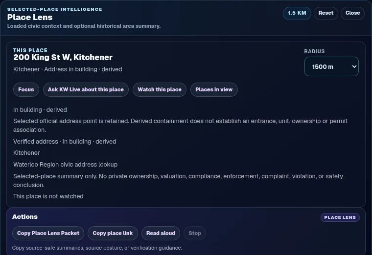
A real place is an intelligence object, not a coordinate. Select an address or a building and Place Lens organizes what the region knows about it around one persistent identity: now, property and development, around, history, watch, sources, and Ask.
Focus view · recorded 10 Sep 2026 · © OpenStreetMap contributors © CARTO · Place Lens panel recorded 8 Oct 2026 from a local preview
03 — Provenance · Ask
See the context.Trace the source.
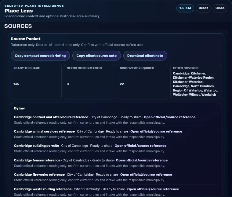
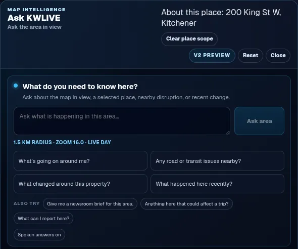
Where it came from, how current it is, whether it is official, reference or inferred, and when it is unavailable. Ask the region about the area in view or one place, and the answer carries the same sources. Nearby is never a relationship.
Official publishers remain the sources of record. KW Live points to them and does not speak for them. Scanner-derived observations are preliminary and not official confirmation.
Backdrop recorded 10 Sep 2026 · © OpenStreetMap contributors © CARTO · panels recorded 8 Oct 2026 from a local preview · stills, not live feeds

04 — Time · City Memory in development
A picture of now.A memory of change.
KW Live is building historical context into the map so regional information can be understood over time: what changed, when a source revised itself, and what was known at a given point in time. City Memory is a direction under development, not a released screen.
Recorded 10 Sep 2026 · WRPS historical public data, 2024 | Public locations published by Waterloo Regional Police Service | Bus routes & stops © Metrolinx (GO Transit GTFS) | © OpenStreetMap contributors © CARTO · a direction, not a released historical-reconstruction screen
05 — How it fits · A federated regional spatial intelligence layer
Built on sources of record.Not instead of them.
KW Live does not ask any organization to replace what it already runs. Municipal GIS remains the source of record for municipal GIS. Transit agencies remain authoritative for transit. Public-safety agencies remain authoritative for their systems. Traffic, fleet and digital-twin vendors can remain authoritative for their domains. KW Live is designed as the connective regional layer above them, built from the start for more than one municipality.
Public and official sources in the beta today · each stays the source of record
- Municipal GIS
- Transit
- Roads
- Infrastructure
- Public safety
- Planning & permits
- Cameras & weather
Persistent place identity · regional context · time · provenance · one picture
What people work with
- Map
- Place
- Situation
- History
- Ask
Designed to sit above systems like these as well, without replacing them · not connected today
- Traffic systems
- Fleet systems
- Digital twins
In the private beta · Waterloo Region
- Live regional map
- Roads & construction
- Transit context
- Public-safety context
- Cameras
- Aviation
- Weather
- Permits & planning
- Municipal GIS layers
- Building reference geometry
- Scanner-derived observations
- Place Lens
- Ask KW Live · text & voice
- Watches
Coverage and update frequency vary by source and municipality. Scanner-derived observations are preliminary and are not official confirmation. Original publishers remain the sources of record.
Reference deployment
Built in Waterloo Region. Designed to learn what a regional intelligence system needs to become.
Waterloo Region is where KW Live is being proven: three cities and four townships, with real municipal GIS, real transit, real roads and real public-safety context. It is in controlled private beta with people who work closest to local information, and it has been used in that beta by a local newsroom.
- Kitchener
- Waterloo
- Cambridge
- Woolwich
- Wilmot
- Wellesley
- North Dumfries
- Municipal & government
See multiple regional systems together, with each one still owned by the organization that runs it.
- GIS professionals
Persistent place identity, time and provenance on top of the layers you already maintain.
- Public safety
Regional context around official sources, with uncertainty and unavailability stated rather than hidden.
- Transportation & infrastructure
Regional context around the intelligence your systems already produce.
- Newsrooms
A source-aware picture of the region, with the source of record one link away.
- People who live here
Understand what is happening around you, and around the places you care about.
Programs & community
- CommunitechFounder member
- Accelerator CentreAC:Incubate
- Google for StartupsCloud program
- AWS ActivateStartup program
- CloudflareCloudflare for Startups
Built with support from, and participation in, startup programs in and beyond Waterloo Region. Program participation and membership do not imply investment or endorsement.
Made in Kitchener
KW Live is the first major software build by founder Mike Nickason. It started in Kitchener in 2026 with a simple idea, that a region should be understandable as one picture, and moved quickly from a live map to a regional spatial intelligence platform in private beta, with an architecture designed for more than one municipality.

Private beta — Waterloo Region
See the regional picture.
KW Live is in controlled private beta with people whose work depends on understanding this region. If that is you, we would like to talk.
Recorded 10 Sep 2026 · © OpenStreetMap contributors © CARTO